


La Grave J2

Airelle
User
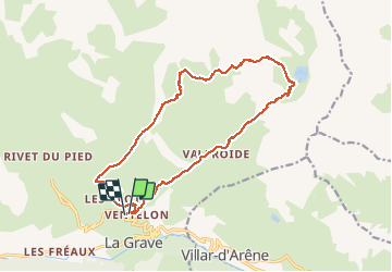

Length
17.3 km

Max alt
2707 m

Uphill gradient
1088 m
Km-Effort
32 km

Min alt
1752 m

Downhill gradient
1089 m
Boucle
Yes
Creation date :
2020-09-21 07:00:16.0
Updated on :
2020-09-21 13:40:09.891
6h38
Difficulty : Unknown

FREE GPS app for hiking
 SityTrail
IGN / Geographical institutes
SityTrail Plus
The world is yours!
About
Trail Walking of 17.3 km to be discovered at Provence-Alpes-Côte d'Azur, Hautes-Alpes, La Grave. This trail is proposed by Airelle.
Positioning
Country:
France
Region :
Provence-Alpes-Côte d'Azur
Department/Province :
Hautes-Alpes
Municipality :
La Grave
Location:
Unknown
Start:(Dec)
Start:(UTM)
287835 ; 4992255 (32T) N.
Comments